
www.rambler-info.org.uk
I am writing this for you, assuming you are a walker. Also, I have assumed that you are using a "proper" GPS rather than a mobile phone.
You will find there are two really good uses for your GPS, apart from being a locating device. One is to store tracks on your computer for future use and to be available to share with your friends. The other is to interact with digital maps that you have purchased.
You must start by spending a little money. You will need a cable to connect your GPS to the computer. For that, I suggest you avoid the Garmin products that cost a lot and still mostly use serial RS232 interfaces, which need adaptors to connect to modern computers via the USB interface. There is one UK company which sells an excellent cable which will connect directly to the computer USB and it costs less than the Garmin RS232 cable!
 Others currently sell this product on Ebay at a price of £12 - £20.
(You should sort through the items listed to find the correct connector at the GPS end)
No further expenditure is required to achieve the aims of storing, viewing and sharing your tracks. There are Freeware programs on the Internet that will let you do this.
Later you may wish to purchase a commercial version of these programs, but that can come later.
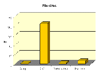 All of these programs will let you view your track on-screen and perhaps an altitude profile or other information, such as waypoints. Most importantly, they let you store your tracks and waypoints on your computer. They will offer several formats for storing the data, but I suggest you use the GPS Exchange Format. Until recently all the many commercial companies in the field would store data in their own proprietary formats, but the GPS Exchange Format was set up as a non-proprietary format and most software will now read and store in this format. You might note that some of the other formats are very much more compact (see diagram on right), but they will not be readable by all software.
Now for the bad news. Digital maps are freely available in the UK, but they cost a lot of money. The policy of the Ordnance Survey seems to be to go for high price licences. They are selling very few maps and I guess they are not making much money on these few sales! You can expect to pay about four times the cost of a paper map for the 25k series. This seems like a policy to suppress sales and to stimulate piracy!
Anyway, if you are rich enough to buy your local area map or one of the National Park maps, you can get the maps plus some very useful software from one of the following licencees.
The pricing policy is a great shame since it is fun to see your tracks being overlaid on the maps and the maps are superb for route-planning. You can sit in front of your computer and click along footpaths to plan a track. The length and, more importantly, the total ascents can be found by using the supplied software. The resulting tracks can be stored and also can be loaded into your GPS, which then can steer you round the walk by pointing forward along your route.
![]()
![]()