
Choosing "Basic navigation" GPS units
With grateful acknowledgement to Garmin©
|
| |
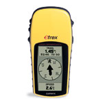 eTrex® H
circa £55 (£70 with USB adapter)
|
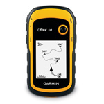 eTrex® 10
circa £100
|
| Unit dimensions, WxHxD: |
4.4" x 2.0" x 1.2" (11.2 x 5.1 x 3.0 cm)
|
2.1" x 4.0" x 1.3" (5.4 x 10.3 x 3.3 cm)
|
| Display size, WxH: |
1.1" x 2.1" (2.8 x 5.4 cm)
|
1.4" x 1.7" (3.6 x 4.3 cm)
|
| Display resolution, WxH: |
64 x 128 pixels
|
128 x 160 pixels
|
| Display type: |
4 level gray LCD
|
transflective, monochrome
|
| Weight: |
5.3 oz (150 g) with batteries
|
5 oz (141.7 g) with batteries
|
| Battery: |
2 AA batteries (not included)
|
2 AA batteries (not included)
|
| Battery life: |
17 hours
|
25 hours
|
| Interface: |
serial
|
USB
|
| Waypoints/favorites/locations: |
500
|
1000
|
| Routes: |
20
|
50
|
| Track log: |
10,000 points, 10 saved tracks
|
10,000 points, 100 saved tracks
|
Notes:
The eTrex H - add another £15 to the price for a USB-converter cable.
(Total price eTrex H about £70 and eTrex 10 about £100)
|
For the extra £30 you get...........
Data storage in Public Domain format (GPX)
So, direct access to all sorts of track-related software!
Huge increase in number of tracks stored
Much faster downloads via USB port
Higher density of track points
Slightly better screen resolution
Improved battery life
But, beware...........
The 100 saved tracks is a bit of a joke.
Yes it might store 100 if each track is a stroll round your garden.
It they are all-day walks perhaps there is room for 20+ tracks.
|
Choosing between Garmin's eTrex GPS units launched October 2011
With grateful acknowledgement to Garmin©
|
| |
 eTrex® 10
c. £100
|
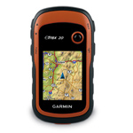 eTrex® 20
c. £165
|
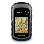 eTrex® 30
c. £210
|
| Display resolution, WxH: |
128 x 160 pixels
|
176 x 220 pixels
|
176 x 220 pixels
|
| Display type: |
transflective, monochrome
|
transflective, 65-K color TFT
|
transflective, 65-K color TFT
|
| Ability to add maps: |
no
|
yes
|
yes
|
| Built-in memory: |
no
|
1.7 GB
|
1.7 GB
|
| Accepts data cards: |
no
|
microSD™
|
microSD™
|
| Waypoints/favorites/locations: |
1000
|
2000
|
2000
|
| Routes: |
50
|
200
|
200
|
| Track log: |
10,000 points, 100 saved tracks
|
10,000 points, 200 saved tracks
|
10,000 points, 200 saved tracks
|
| Electronic compass: |
no
|
no
|
yes (tilt-compensated, 3-axis)
|
| Barometric altimeter: |
no
|
no
|
yes
|
Photo navigation
(navigate to geotagged photos): |
no
|
yes
|
yes
|
| Custom maps compatible: |
no
|
yes
|
yes
|
Unit-to-unit transfer
(shares data wirelessly with similar units): |
no
|
no
|
yes
|
|
Choices...........
Mainly whether ability to use (expensive) maps is present
The 20 and the 30 can archive tracks in internal memory, which the 10 does not possess.
In this case the "200 saved tracks" is OK if these are archived tracks. See above for eTrex 10.
Once tracks are archived they are safe but cannot be used for navigation purposes on the GPS. One must attach the GPS to a computer by USB. It should then be possible to reinstate the tracks for navigation, if space permits.
The removable data card holds maps but has no direct access from the GPS.
A missed opportunity for storing extra tracks and information. Useless!


|