|
Garmin is a strange company. They dominate the GPS market and sell a wide range of GPS units. However they show little formal interest in what the purchasers are going to do once they have bought their GPS unit. The company manuals give very little advice and totally fail to mention many of the useful routines that are built in to the firmware of their products. Consequentially, owners experience strange things when they are using their GPS and they can miss-out on some useful facilities that are present.
The items below are a random list of "discoveries" that have been made in Garmin GPS units.
1... "Sometimes I get map references appearing at the top of my Map Screen" 
If you press the Thumb Stick upwards then your current position will appear across the top of the screen as a Grid Reference. If you want to clear it then press the "Back" button.
If you do not clear the message but move the Thumb Stick to another place on the screen and press it again you will get a compass-like screen directing you to the second point. Getting back to the map screen is awkward.
2... "I get funny little white arrows in my Map Screen"
They are apparently telling you that you are going uphill ↑ or downhill ↓. If anybody can tell me how to switch off the useless things then I would love to know! ........... Message form here
3... "My GPX files have meaningful titles but my GPS labels them by date"
Inside each GPX file is an item called a name. It is invisible until you open the file with a text editor, like Notepad or WordPad. It is this title that the eTrex 10/20/30 units display and not the more accessible filename.
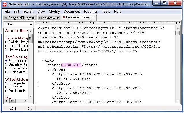
In the above example GPX file (opened in Note-Tab Light), the text labelled with a pink background is what an eTrex 10/20/30 will display. The text shown is very readable since Gartrip software produces user-friendly files. Other software may leave out the punctuation (tabs and carriage returns) and the file will be harder to read than the one displayed here.
The file being edited was actually called PyramidenSpitze.gpx but will be listed on a Garmin GPS as 06-AUG-03. You can alter this internal name to whatever you wish by using a text editor.
(Beware - some software creates GPX files with poor readability. If you are unlucky then search for the <name> tag to find the bit you need to edit.)
4... "When following a track, my current position sometimes goes off-screen"
As you probably realise, when using the Map | Go routines, your own position should stay central on the screen. Sometimes this stops happening and your current position marker eventually goes off-screen. One guaranteed solution is to repeat the Map | Go routine to reset the GPS. However, the problem can usually be put right with a single key-press. Click here to find how.
5... Software for estimating the total ascent of a walk gives values that are too high.
The GPS system was optimised for best horizontal accuracy but still gives useful results for the altitude. However, the scatter on a horizontal track can usually be ignored since an energetic day in the Peak District will perhaps cover 20,000m horizontally. The equivalent vertical journey will be more like 500m so the scatter is getting serious and the vertical scatter is worse than the horizontal scatter! (This is why Garmin sells GPS models which track atmospheric pressure for the altitude values)
Happily there is a very easy answer. Click here to see it.
6... On an eTrex 10 a part of the track is obscured by a grey area.
Dreadful! Garmin ought to fix this! The problem is that the eTrex 10 has a very crude map built in to the system. It is so crude that water being shown as sea or lake can often cover big areas of dry land. The grey area is almost certainly one of these.
There is a work-around of sorts. If you go to the Setup menu and select Maps then you will see that Marine Colours can be switched off/on. If you toggle this setting then the other half of your track will be obscured instead, so you can now navigate in the previously invisible area.
Wake up Garmin! This urgently needs fixing! Even if you cannot get a full fix then please at least provide an option for switching off your miserable backgound map.
(The same problem can be seen on the eTrex 20 and eTrex 30, but the use of colours means that the track is not fully obscured.)
7... How to avoid an expensive problem on eTrex 20 or 30
The metal retention device for the micro SD card is unreliable. I have now met three owners who have had the card drop out unnoticed. Very expensive if it contains commercial maps! I suggest you cut a small piece of Sellotape to stick on top of the retention device.
Click here to make a request or report a problem


|