|
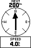
Diagrams above are those for older Garmin GPS units
The most useful thing a walker can do with a GPS is to use it to follow a stored track.
The stored track in your GPS could have come from many different sources: it could be a commercial or freeware walk off the internet, a walk done by a friend, a walk you have constructed using a digital map, or a walk you have done yourself in the past and stored.
It will have been loaded from a computer to your GPS. Once there and called up to run, all you will have to do is to walk in the direction the big arrow points or steer the arrowhead (i.e. yourself) across the map and you will eventually complete the walk.
I have a number friends who I have introduced to track-navigation and they all found it easier than expected. They also found it and very effective and helpful. Problems were minor but there were a few. So, may I offer the following advice?
1... Do not stand still 
When using a magnetic compass, people usually stop to have a better look at their compass and surroundings. With a GPS you should never do this. If you do the arrow will point in various random and meaningless directions. It will do so until you begin walking again. Any direction will do. The GPS can soon tell you that if it was the wrong direction and it will put you right in under 5 seconds.

2... Do not worry if the arrow wavers a little
This is perfectly normal for the arrow to waver and there is a good reason. Just keep going in the general direction previously indicated and all will be well. This is particularly easy if you can see a footpath or track in front of you!
3... Signal loss and false positions
A GPS will not work if it is not getting signals from a sufficient number of satellites. If you are near any big cliffs, then these may block the signal. Less obviously, leafy trees are a big problem. They rarely stop the signals completely, but they frequently result in "rogue" readings. (Here we are talking about rogue readings in the current position worked out by the GPS.)
Avoid the "compass-like" display and use the "map" display instead. Nearly all GPS models will show a dotted track of your previous movements on this display. Use it to help plan your future moves until you get into an area with better satellite signals. Of course, any cliffs or steep valleys will themselves be a useful guide for navigation.

4... Errors in the track being used
If you have loaded a track consisting of data gathered by a GPS rather than one produced on a digital map, there could be "rogue" points included in the track. (See previous item)
Again, change to "map" view and keep your wits about you! If you suspect there are rogue points in the track then you are going to have to ignore the GPS and continue forwards until such time as it gets a valid point or reading.
5... Total loss of signal
All the GPS models (I have owned 8 of them) will, on very rare occasions, decide they cannot see any satellites even though conditions are ideal. I suspect this is the equivalent of a computer crash.
My current advice is to switch the unit off, wait at least 20sec for existing calculations to die, and then switch it on again. Your position will usually be re-established very rapidly, since the unit will cross-check on the last known position. So far this has always resulted in the return to normal service. If it does not work first time, keep the unit switched off a little longer and try again.
(I did once have a failure persisting over 30mins and I have always presumed that the satellite system itself had been in trouble on that occasion. It has been the only such occasion I have seen in 12 years.)
6... Navigating closed loop tracks
When using the "compass-like" display on a closed loop track the unit may tell you, as you set off, "Your have now arrived at your destination".
Walk at least 50m along the track and set up the navigation again. It will work!


|